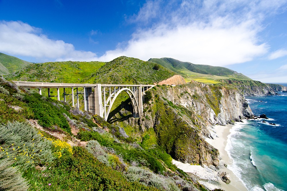
Bixby Bridge
Planning a western states getaway? Make your trip through Washington, Oregon or California a remarkable journey by discovering some of these extraordinary routes, set aside as an American heritage for travelers to treasure.
National Scenic Byways include 233 highways across the US specially designated, preserved and celebrated by the Federal Government for their scenery, historical value and timeless road trip experiences for everyone.
Within these, All-American Roads are a special classification of particularly lovely scenic routes. The West coast states are home to 26 of these National Scenic Byways.
Gorgeous highways are yours to enjoy just by taking the time to plan your trip and turn onto the routes. Generally, these byways add no extra cost to your trip (though many of the roadways travel through National Parks and an entrance fee is charged), providing pocket-friendly family memories and fun in stellar landscapes.
The choices for fun seem endless and the beauty unimaginable. Collect your own experiences and memories on America’s fabulous scenic roads.
WASHINGTON STATE ROADWAYS
The farthest northwestern state features two All-American Roadways and six National Scenic Byways.
The Cascade Loop National Scenic Byway: This loop route circles from the salt waters and beaches of Puget Sound, climbing over two of the most stunning mountain passes in the world. It curves down on the East into the fertile orchards and seemingly endless grain prairies of central Washington.
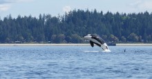
Orcas puget sound
Orcas, whales and salmon can be viewed on the western end of this route, and bellowing elks, bighorn sheep and mountain goats on the heights. Peaks of sleeping volcanoes remind the traveler that the Cascades are an edge of the Pacific Ocean’s volcanic ring of fire with their gleaming, snow-covered cones.
Chinook Scenic Byway (All-American Roadway): The highway travels through the volcanic Mt. Baker-Snoqualmie National Forest and Mount Rainier National Park.
The drive includes diverse landscapes of the Central Cascades. Your drive meanders from Enumclaw and the glacier-fed White River Valley to the west, then over 5,430 ft. Chinook Pass. “It descends to the fertile valley of Naches to the east side of the Cascade range” declares the website.
In spring and early summer, stunning wildflowers spill their paint over the mountain meadows for an extra attraction on this amazing trip.
International Selkirk Loop (All-American Roadway): An impressive tour of the second large mountain range in Washington, the saw-toothed Selkirk Range of the Rocky Mountains located in the state’s northeast corner.
Plan on traveling through a chunk of Idaho and crossing into Canada’s British Columbia during the loop. A free ferry takes you and your vehicle across Kootenay Lake. (Don’t forget your passport.)
Coulee Corridor National Scenic Byway: Nature’s contrasts are showcased in this 150-mile route traversing basins and plains, colorful painted canyons, rivers and lakes scoured out by vast ancient floods and ice. “Between three state parks, a national wildlife refuge, visits to the Grand Coulee Dam and Lake Roosevelt National Recreation Area, or Othello’s Sandhill Crane festival, you’ll find something for the whole family” says the website. An amazing trip, very different from the moist Pacific side of Washington.
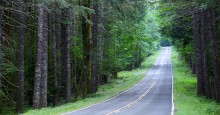
forest road
Mountains To The Sound Greenway, National Scenic Byway and National Heritage Area: Follow I-90 from the Seattle metro area over the Cascades, dropping through verdant valleys towards the Columbia River plateau.
Retrace the trail of pioneers on the Oregon trail seeking new homes or miners hurrying to set sail for the Klondike Gold Rush. During spring through autumn, enjoy strolls along the stark passes or more strenuous treks on the Pacific Crest Trail as it crosses the highway. Winter sports abound on the snowy mountains; check out the weather before you travel in the cold months!
Stevens Pass Greenway, National Scenic Byway: This is a trip through rugged contrasts—starting by green Puget Sound near Everett, the southern part of the Cascade Loop NSB travels along the wild and rugged Skykomish River.
The route continues over high Stevens Pass to drop into the historic towns in Tumwater Canyon and Wenatchee River Valley. Enjoy Orcas and beaches on one end, and farm produce, harvest or wine festivals and luscious fruits of Washington’s prairie on the other end of this Byway.
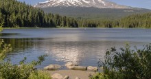
mount hood
Strait of Juan De Luca Highway, National Scenic Byway: Running along the northern edge of the Olympic Peninsula, the busy ocean waterway to Seattle features orcas, whales, beaches, lakes and stark mountains with a background of shipping from all over the world.
Fish for salmon, learn about ancient native cultures, paddle lakes, enjoy forest or shoreline strolls or backpack in Olympic National Park. This route is a true gateway to all-year adventure.
White Pass National Scenic Byway: Starting south of Seattle, this route is considered one of the best opportunities to view wildlife from your vehicle in the state of Washington.
Drivers may spot mountain goats and bighorn sheep effortlessly scaling cliffs, golden and bald eagles snagging salmon on alpine lakes. Views include the backside of Mount Rainier on this 120-mile roadway. Abundant camping, hiking and recreation pastimes are available if you choose to linger.
OREGON STATE ROADWAYS
Join travelers from Lewis & Clark to pioneers bound for the wild west where four historic, beautiful All-American Roadways and six National Scenic Byways help you thoroughly explore Oregon.
Hells Canyon National Scenic Byway (All-American Roadway): Stark beauty and history combine on a 218-mile route along the Oregon Trail towards the Snake River rushing through America’s deepest river canyon.
crater lake
Enjoy historic wagon train reenactments, volcanic peaks covered in snow, sightings of herds of buffalo and elk and side trips where you can camp, water-ski, horseback ride or hang-glide. Plenty to do and see on this gorgeous highway.
Historic Columbia River Highway (All-American Roadway): A length of the old route takes you along the canyon rim where you can view the Columbia River, Multnomah Falls and part of the Oregon Trail.
For future road trip planning, this park is famous for stunning displays of wildflowers in spring. Close to the metro area of Portland, many miles of trails for strollers or hikers of every ability provide mountain-to-ocean panoramas.
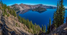
Volcanic Legacy Scenic Byway (All-American Roadway): This road winds from Crater Lake National Park past pointed and snowy volcanic peaks in the Cascade Range. It ends with a view of Lassen Volcanic National Park over the California border.
This road has spectacular scenery, lovely mountain towns, abundant wildlife to view and plenty of exciting geology and fun along the way.
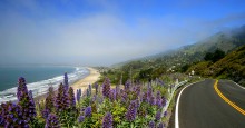
Pacific Coast Scenic Byway (All-American Roadway): Take in the whole breath-taking Oregon Coast in one winding and twisting adventure. The 363 miles of roadway meanders past white beaches, coastal mountains and towns.
california coast
You might see salmon-choked rivers, catch glimpses of spouting whales from your car, fly kites or kayak down long shores. Spend a day on an ocean fishing trip and camp in lush valleys. Indulge yourself in world-class restaurants and hotels. Plan to spend lots of time on this trip.
Cascade Lakes National Scenic Byway: There are more than 150 lakes on this 66-mile roadway. But don’t rush past the volcanoes, forests, ancient glaciers, alpine meadows and mountains. Take time to explore this central Oregon gem.
Mount Hood National Scenic Byway: The snowy volcano cone broods over the Columbia River at its foot and the city of Portland towards the sunset. The sight is a surprisingly varied wonderland of deep canyons, snowy mountains, rain forests and wild rivers. Great for a day jaunt or choose to extend your stay in the historic log Lodge at the peak. Take a white water rafting trip or meander down adjacent canyons.
Mackenzie Pass - Santiam Pass Scenic Byway: Drivers can see lava fields between six volcanic peaks, with Sahalie and Koosah falls visible right from your car. The attractions on this 82-mile highway in central Oregon include crystal lakes that mirror the conical-shaped mountains. Take time to paddle, camp. Or hike the lava flows, mountain meadows and forests.
Outback Scenic Byway: View mesas, mustangs, sagebrush, ranches and cowboys. The stark high prairie and lonely roadways whisk you back in time.
open road mountains
The highway angles southwest towards the California border and brushes against mountains jutting up from the plain. See sky-mirroring lakes with seasonal flocks of birds where herds of deer, pronghorns and antelope gallop through miles of the legendary American West.
Rogue-Umpqua Scenic Byway: A lush loop angles away from busy Interstate 5 into the mountains, along some of Americas’ most exciting whitewater rivers. It courses through dense forests and back to the rolling, oak-covered foothills.
These two designated “Wild and Scenic” rivers cut through canyons and lava flows, past world-class fisheries and historic logging towns. Wineries, stellar dining and accommodations are available in the Medford and Jacksonville areas at the end of this route.
West Cascades Scenic Byway: Enjoy thundering waterfalls, jutting mountains, whitewater rivers and historic logging towns from your car. Or get out and extend your trip by adding an adventure you experience yourself. Some of the largest stands of old-growth forest are preserved along the “Wild and Scenic” Clackamas River.
CALIFORNIA STATE ROADWAYS
The Golden State features three All-American Roadways and five National Scenic Byways – all of them memorable.
Big Sur Coast - Route 1 Scenic Byway (All-American Roadway): You have seen this highway on endless magazine covers; it is better by far to drive it yourself.
california desert
Robert Louis Stevenson aptly named this coast “…the most beautiful meeting of land and sea on the earth.”
Big Sur offers fog-laced mountains, towering redwood trees and wind-twisted Cyprus trees perched over deep cliffs. Walk white beaches and wade in breaking surf or just gaze at the astounding views from your car.
View migrating gray whales, barking sea lions and cavorting otters. Big Sur National Park and many state beaches entice picnickers to linger and beckon hikers and kayakers. Weekends can be very congested, so plan your trip accordingly.
Volcanic Legacy Scenic Byway (All-American Roadway): Two active volcanoes steam and bubble next to this fabulous loop trail; Lassen National Park and Mount Shasta on the skyline.
See the spectacular sites from your car, or take a trail past boiling mud, spouting geysers and hot springs. You can extend your trip north through Oregon to Crater Lake National Park.
Or travel west through Modoc, Klamath, Shasta, Pit and Wintu first-nation tribal lands. Gaze at giant boulders spewed out of Lassen peak during the last eruption in 1915.
Arroyo Seco National Historic Parkway - Route 110: Situated in the middle of a major metropolitan area, this historic route connects Los Angeles and Pasadena. It offers glimpses of the lovely, stark canyon that is the site of famous Arts & Crafts era mansions.
Avoid traffic issues in the Los Angeles basin and plan your excursion during non-commute hours.
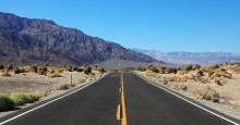
Death Valley Scenic Byway: Highway 110 travels west from this Death Valley National Park (the lowest spot in the US) to just opposite the Sierra’s Mt. Whitney, the highest peak (14,505’) in the lower-48 states.
Death Valley is 3.3 million acres of painted desert, beautiful sand-dunes and slot canyons. The night sky features one of the most pristine opportunities for star-gazers in the US.
Explore the beautiful route in all seasons in your car, stroll over boardwalks through the sand dunes, hike the canyons or get off-road for an adventure of a lifetime.
Ebbetts Pass Scenic Highway: Bookended by two California parks–Grover Hot Springs near Lake Tahoe in the eastern and Calaveras Big Trees on the western end–this meandering route takes drivers through stunning vistas of the Sierra Nevada range.
Note: Summer roads are clear but the highway is not open in winter.
California Historic Route 66 - Needles to Barstow National Scenic Highway: American songwriter Bobby Troup penned the famous song, “(Get your kicks on) Route 66,” in 1946. It still holds true today on this preserved section of the original 2400-mile historic highway.
View the lovely “high desert” mesa, sand and canyon scenery so familiar from classic western movies. Millions of migrants fled the Dust Bowl in the 1930s for a new life in California and cemented a place for this highway forever in our national memory.
Tioga Road - Big Oak Flat National Scenic Byway: This highway winds right through Yosemite National Park and passes by sublime Tuolumne Meadows with its stark rugged alpine canyons, flowery meadows and wild river.
The highway’s eastern end abuts Mono Lake, skirted by the unique, geologic salt-tower formations of Tufa. Extend your trip by taking the Generals Highway to see spectacular, endangered Giant Sequoia trees. Visit the Yosemite Valley for an unforgettable experience.
Tioga Pass is subject to storms even in summer and routinely closes early in winter. Check road conditions.
See all these national treasures on the scenic.org website. The NPS.gov website has more route suggestions and attractions listed for each Scenic Byway. Accommodations, fun things to do, year-round recreation, great food and wine-tasting suggestions are available on local tourism sites.
Copyright © 2024 by Sensible Driver. All rights reserved.